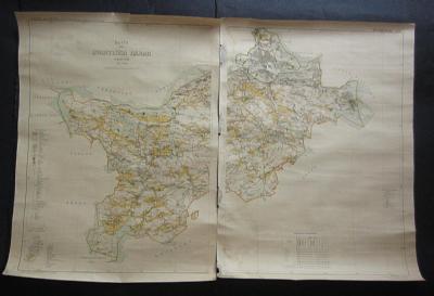
[Map] Rikets Allmäna Kartverk / Ekonomiska kartverket.
Karta öfver Svartlösa härad uppmätt 1906.
På bekostnad af Stockholms Läns Hushållningssällskap. Graverad och tryckt vid Generalstabens Litografiska Anstalt år 1912. 2 map leaves each 79 x 59 cm. Can be assembled to form a large wall map. Printed in fine colour lithography.
A few tears and small losses in the margins. One tear just into the map area. A few discreet water stains. One margin with some mould staining.
The map covers the city of Stockholm and large parts of what is now the southern suburbs, from Botkyrka in the west to Saltsjöbaden in the east and from Orlången in the south to Stockholm proper in the north. The map shows in great detail all the farms, cottages, tracks, roads, train lines, farm lands, forests and lakes as well as the jurisdictional borders. Many of the old place names have been retained in the modern suburban names. It gives great opportunity to study the development of the area. An endless treasure of information for anyone interested in the history of Stockholm. Furthermore the map is quite beautiful. It was published for the work "Häradskartor öfver Stockholms Län" which in turn ia a part of the "Ekonomiska Kartverket" a never finished attempt to survey the entire country.
Item No: 3984